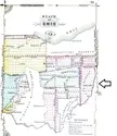

Arrow points to The Seven Ranges
A vintage map of the state of Ohio detailing the Seven Ranges, which were the first seven columns of townships surveyed in the Northwest Territory. The document shows historical land reserves, military reservations, and early city locations.